Leica Geosystems iCON solution addresses the complex demands of modern building construction by providing integrated solutions that enhance productivity, accuracy, and workflow efficiency across all positioning and measuring tasks. These solutions improved accuracy and precision along with enhanced productivity through automated processes and one-person operation.
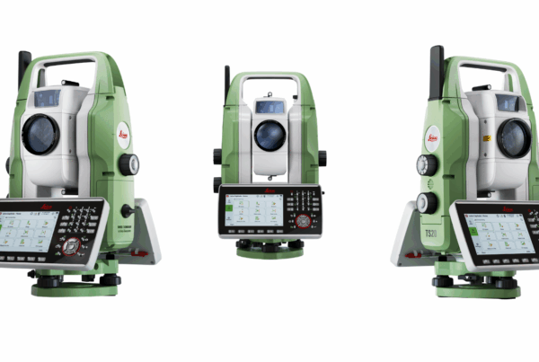
Leica iCON iCR70 – Precision Robotic Total Station
The iCR70 represents a significant advancement in construction layout technology, facilitating the transition from analog-to-digital measurement methods essential for contemporary BIM processes. Key specifications include:
- Angle Accuracy: 2″ and 5″ absolute
- Distance Accuracy: 1mm + 1.5ppm (prism), 2mm + 2ppm (non-prism)
- Measurement Range: 1.5m to 3500m (prism), 1.5m to >500m (non-prism)
- ATR Range: 1000m (circular prism), 800m (360° prism)
- Coaxial Visible Red Laser: 8mm x 20mm dot size at 50m
The iCR70’s automated setup routine via the Setup Pilot app eliminates user interaction requirements, ensuring consistent configuration accuracy. The system SpeedSearch functionality provides 300m range with typical 7-second search times for 360° prisms. This automation reduces setup time and minimizes human error, allowing construction teams to focus on layout tasks rather than instrument configuration.
![]()
The instrument weighs 5.0kg including battery and features a 4-button keyboard with status LEDs for straightforward operation. Communication capabilities include RS232, USB, Bluetooth®, and WLAN interfaces, ensuring seamless integration with field controllers and office systems.
The iCR70 robotic capabilities enable single-person operation across complex construction environments. The instrument’s intelligent tracking system maintains target lock even in challenging conditions, while the automated measurement sequences reduce operator fatigue and increase throughput. The system’s integration with BIM workflows ensures seamless data transfer between design models and field measurements, maintaining design intent throughout the construction process.
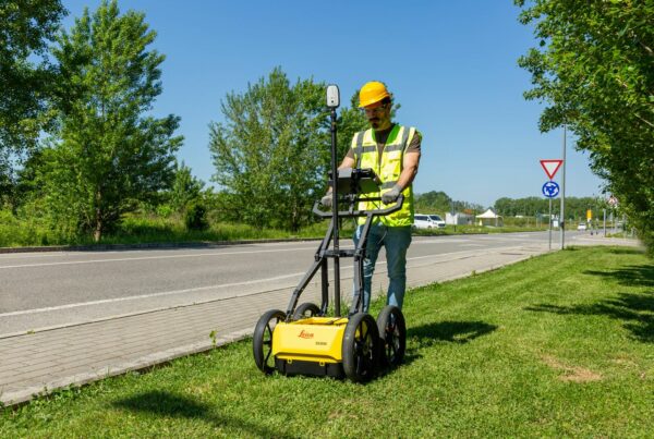
Leica iCON iCG70T – Advanced GNSS Construction Rover
The iCG70T integrates cutting-edge GNSS technology with an inertial measurement unit (IMU) for comprehensive positioning solutions. This GNSS rover system addresses the complex positioning requirements of modern construction projects while delivering the reliability and accuracy demanded by professional contractors:
- Permanent Tilt Compensation: Calibration-free operation resistant to magnetic interference
- 555 Channels: Enhanced signal acquisition and sensitivity across multi-frequency, multi-constellation systems
- SmartCheck+ & SmartTrack+: Unique RTK technology providing continuous validation
- Environmental Rating: IP66/IP68 protection, operating range -40°C to +65°C
- Initialization: Seconds-based startup with complete reliability
![]()
The iCG70T weighs 1.20kg (3.50kg standard RTK rover setup on pole) with dimensions of 173mm x 173mm x 108mm. The exchangeable Li-Ion battery (2.8 Ah / 11.1 V) provides 7 hours of operation when receiving data with internal radio, 5 hours when transmitting data with internal radio, and 6 hours for combined receive/transmit operations with internal phone modem.
Environmental durability includes resistance to drops from 2m survey pole onto hard surfaces, strong vibration resistance (ISO9022-36-08 / MIL STD 810G 514.6 Cat.24), and functional shock resistance of 40g / 15 to 23 msec (MIL STD 810G 516.6 I).
Leica AP20 AutoPole Integration – Leica iCR70 Total Station
The AP20 AutoPole system eliminates analog workflow components through three primary functions:
Tilt Compensation: Enables measurements without pole levelling, increasing flexibility and productivity for upside-down and hidden point measurements.
PoleHeight: Automatic pole height updates eliminate manual reading errors with +/- 1.0mm accuracy at snap-lock positions.
TargetID: Automatic target search, identification, and lock functionality prevents incorrect target acquisition on busy multi-crew sites.
Technical Specifications
- Tilt Range: +/- 180° with typically 1mm + 0.1mm/° tilt uncertainty
- Operating Range: 300m to total station, 150m for TargetID
- Power Management: 16-hour operation (AP20 H/ID), 6-hour operation (AP20 T/AP20)
- Environmental Rating: IP67, -30°C to +60°C operating range
Use with additional Leica CCD18 Radio Handle designed to support Bluetooth low energy for AP20 AutoPole with Tilt Compensation. Establishes communication to field controller CS30/CC70/CC80 or external radio modem TCPS29/30. Frequency range 2402 – 2480 MHz.
![]()
Leica iCON Build Field Solution
The iCON Build software is a central system for construction measurement workflows, providing application-specific functionality that addresses the diverse requirements of modern building construction. This comprehensive software suite transforms raw measurement data into actionable construction information while maintaining seamless integration with BIM processes.
Points and MEP Layout Applications
The Points & MEP Layout functionality is specifically optimized for mechanical, electrical, and plumbing applications, featuring auto-selection capabilities and comprehensive tolerance checking. The software provides intuitive navigation to hangers, slits, inserts, conduits, and outlets with color-coded quality indicators that immediately communicate measurement status to field personnel.
The system’s intelligent layout algorithms optimize measurement sequences, reducing travel time and improving productivity. Tolerance checking ensures that all installations meet specification requirements, while the color-coded interface provides immediate feedback on measurement quality and compliance status.
As-Built Documentation and Data Capture
The As-Built Documentation module enables single-step capture of points, lines, and arcs with immediate graphical representation. The system applies automatic code application and measurement storage with unique Start/Stop line features that accelerate documentation processes significantly.
This capability transforms traditionally time-consuming as-built documentation into an efficient, streamlined process. The immediate graphical representation allows field personnel to verify documentation accuracy in real-time, reducing the need for return visits and improving overall project efficiency.
Layout Lines and Control Systems
The Layout Lines functionality provides comprehensive line layout capabilities for control lines, parallels, perpendiculars, and arcs. The system supports both horizontal and vertical offsets with string stakeout capabilities for elevation reference, enabling complex layout tasks to be completed efficiently.
This versatility ensures that construction teams can handle diverse layout requirements using a single software platform. The system’s ability to manage complex geometric relationships simplifies traditionally challenging layout tasks while maintaining the accuracy required for professional construction applications.
Verification Workflows and Quality Control
The Verification Workflows module provides real-time field comparison capabilities with optimized heatmap visualization for tolerance analysis. This powerful feature enables immediate quality assessment and provides direct export and reporting functionality for project progress tracking.
The heatmap visualization transforms complex tolerance data into easily interpreted visual information, enabling quick decision-making in the field. The system’s ability to generate immediate reports supports quality control processes and provides documentation for project management requirements.
Volume Calculations and Site Analysis
The Volume Calculations module delivers accurate volume computation for stockpiles, pits, and surface comparisons with compaction factor application and balanced site elevation analysis. This functionality supports excavation planning, material management, and site preparation activities.
The system’s advanced algorithms ensure accurate volume calculations while providing the flexibility to apply compaction factors and other adjustments required for accurate material planning. The balanced site elevation analysis capability supports efficient earthwork planning and execution.
![]()
BIM Integration and Object-Driven Layout
The Layout Objects app enables direct utilization of IFC design models, maintaining object meta-data throughout the construction layout process. This object-driven approach provides direct IFC data loading from MEP/BIM design software with graphical object selection for immediate layout initiation.
The unique “Zlider Bar” (a slider in the z-axis) feature simplifies complex design data visualization, enabling efficient navigation through complex 3D models. The system’s flexible work package creation with full 3D model rendering ensures that field personnel can access and understand design information effectively.
The system addresses common construction data challenges through enhanced coordination between VDC/BIM design teams and field construction experts. Information preservation maintains critical constructible information through non-standard data set processing, while model simplification reduces data overload while preserving essential design model information.
Data Format Support and Compatibility
The iCON Build software provides comprehensive file format compatibility, including import capabilities for DXF, DWG, DGN, and IFC formats with no prior conversion requirements. Export functions enable direct CAD/BIM data export for office operations, maintaining seamless data flow between field and office environments.
Layer management capabilities provide unified handling of layers and files through MapOPS+, while model filtering tools including Tree view, Limit box, and isolate functions enable efficient management of complex design data. This comprehensive approach ensures that construction teams can work effectively with data from any source while maintaining accuracy and efficiency.
Cloud Connectivity and Data Management
The Leica ConX cloud-based collaboration platform provides real-time data exchange capabilities, enabling seamless 3D data sharing between office and field operations. The system supports remote field crew assistance and monitoring while providing comprehensive progress tracking through as-built data recording and office reporting capabilities. Reference data management ensures reliable, up-to-date design data distribution across all project stakeholders.
The Leica iCON Understanding Construction system represents a fundamental shift in construction measurement technology. By integrating advanced hardware, intelligent software, and cloud-based collaboration tools, the platform enables construction professionals to achieve unprecedented levels of accuracy, efficiency, and productivity. The system’s object-driven approach to BIM integration, combined with comprehensive measurement capabilities, positions it as an essential tool for modern construction workflows.
The transition from analog to digital measurement methods is no longer optional—it’s essential for competitive advantage in today’s construction environment. The iCON ecosystem provides the comprehensive solution needed to meet these demands while ensuring long-term value through its scalable, interchangeable platform architecture.
Survey Instrument Services is committed to empowering our customers with extensive training opportunities. We provide a complete range of professional training courses designed to maximize your equipment proficiency and operational efficiency.
Available Training Programs: https://sisirl.com/services/training-courses/
For detailed course information, scheduling, and customized training solutions, please contact either of our offices. Dublin (01) 456 8650 / Cork (021) 423 2957