
Digital Levels
Showing the single result
No matter the project demands, Leica Geosystems digital levels provide the right combination of simplicity, power and precision to accelerate your layout and leveling tasks. Streamline residential and commercial construction or topographic surveying by going digital with Leica levels.
You may also find of interest: Receivers, Accessories, and Laser Levels
-
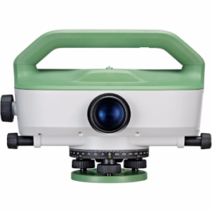
Leica LS10 Digital Level
€5,895.00 excl VAT (€7,250.85 incl VAT)
- What are the key features of Leica Digital Levels?
- How do Leica Digital Levels improve efficiency in levelling tasks?
- Which models of Leica Digital Levels are available?
What are the key features of Leica Digital Levels?
- High accuracy (up to 0.2 mm with LS15)
- Electronic level bubble for precise setup
- Automated functions like autofocus and tilt checks
- Digital camera for fast staff sighting (LS15)
- On-board memory for data storage
- USB and Bluetooth connectivity
- User-friendly interface with multiple languages
- Compatibility with office software for data processing
How do Leica Digital Levels improve efficiency in levelling tasks?
Leica Digital Levels improve efficiency by:
- Automating measurements with one-button operation
- Reducing human errors through digital readings
- Enabling faster staff sighting with digital cameras (LS15)
- Providing built-in calculations for delta height, cut & fill, and line leveling
- Allowing for data storage and easy transfer to office software
- Operating in poor light conditions
- Streamlining the leveling process with guided workflows
Which models of Leica Digital Levels are available?
The main models mentioned are:
- Leica LS10 & LS15 Digital Levels: High-precision instruments for demanding leveling applications
- Leica Sprinter 250m: Versatile digital level with built-in memory and various calculation functions


