Leica Flexline Manual

Showing the single result

Total Stations | Leica Flexline

At SIS we offer the full range of Leica FlexLine Total Stations from Leica Geosystems. These high-quality, durable instruments provide top performance and precision for demanding survey and layout tasks across various industries.

You may also find of interest: Hire iCON Robotic, Hire Controllers and Accessories. 
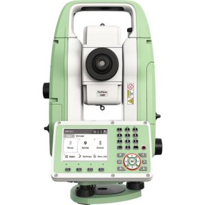
What are the key benefits of Leica FlexLine Total Stations?
+ -

The key benefits of Leica FlexLine Total Stations include:

  1. High precision and performance for demanding measurement tasks
  2. Exceptional durability, reducing downtime and increasing planning certainty
  3. Increased efficiency, allowing surveyors to measure more points per day
  4. Compatibility with advanced software like Leica Captivate or FlexField
  5. Low total cost of ownership
  6. Option for AutoHeight feature for automatic instrument height measurement
  7. Global service and support network
  8. Integration with modern 3D dataflow and quality assurance routines

These benefits make Leica FlexLine Total Stations versatile tools for various surveying, construction, and engineering applications, offering reliability and improved productivity.

How does the AutoHeight feature improve efficiency?
+ -

Automatic measurement

It enables the instrument to automatically measure, read, and set its height.

Time-saving

It eliminates time-consuming manual effort in measuring instrument height.

Error reduction

By automating the process, it helps eliminate critical errors during instrument setup.

Precision

It uses a laser from the instrument to measure to the ground accurately.

Seamless integration

The measurement is automatically passed to the software, ensuring data consistency.

Streamlined workflow

It simplifies the setup process, allowing surveyors to start their main tasks quicker.

Reduced training needs

The automated process requires less expertise to perform accurately.

By automating this crucial step in the setup process, AutoHeight significantly enhances overall efficiency and accuracy in surveying tasks.