
UAV/Drones
Professional commercial UAS / UAV / Drones are today performing missions of surveying, mapping, city-planning, mining, forestry, agriculture, volume calculations, science, wildlife protection and much more. Discover industry-leading drones and accessories at surveydrones.ie, your one-stop shop for professional UAV solutions.
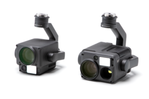
DJI Payloads capabilities
- Triple-sensor solution
- 20MP zoom camera
- 12MP wide-angle camera
- 1200m laser rangefinder
- Suited for general inspection and public safety tasks
- Multi-sensor flagship payload
- 48MP wide-angle camera
- 40MP zoom camera (up to 34x optical, 400x digital zoom)
- 3000m laser rangefinder
- Infrared thermal camera (H30T variant)
- NIR auxiliary light
- Ideal for advanced inspection, public safety, and night operations
- Specialized for photogrammetry
- 45MP full-frame sensor
- Interchangeable 24/35/50mm lenses
- Global mechanical shutter
- High-precision TimeSync 2.0 system
- Optimized for mapping, surveying, and 3D modeling applications
DJI Enterprise drones in construction
DJI Enterprise drones revolutionize construction projects with aerial surveying, site monitoring, and progress tracking. Models like the Matrice 300 RTK and Mavic 3 Enterprise offer high-resolution imaging, LiDAR capabilities, and extended flight times.
These drones feature obstacle avoidance systems, RTK positioning for centimeter-level accuracy, and multi-sensor payloads for thermal imaging and 3D mapping. With IP-rated designs for harsh environments and intelligent flight modes, they streamline site inspections and data collection.


